Kızılırmak is the longest river that originates and flows within Turkey's borders, beginning in the Imranlı district of Sivas and eventually emptying into the sea in the Bafra district of Samsun. The river is notable for irrigating exactly 10 cities along its path and forming the Kızılırmak delta at its endpoint. Along the river's course, there are 12 dams and hydroelectric power plants which are of great importance in the country's energy production. Additionally, the river plays a significant role in irrigating the agricultural lands in the provinces through which it flows.
Kızılırmak: Turkey's Magnificent River That Connects 10 Cities to the Sea

0
Information About the Kızılırmak
Kızılırmak is born on the outskirts of Kızıldağ, located in the Imranlı district of Sivas. It also pours into the sea in the Bafra district of Samsun. With a total length of 1355 kilometers, this river is the longest river in Turkey that was born within its borders and flows into the sea within its borders.
The Kızılırmak passes through the following cities:
Sivas
Kayseri
Nevşehir
Kırşehir
Kirikkale
Ankara,
Çankırı
Corum
Sinop
Samsun
Kizilirmak, Delice River, Devrez and Gökırmak, including a large number of streams by collecting in itself and pouring into the sea. There is a delta of 56,000 hectares in the area where the Kizilirmak flows into the Black Sea. The name of this delta is Kızılırmak Delta. The Kızılırmak Delta is one of the most important wetlands of Turkey.
There are 12 dams and hydroelectric power plants on the Kızılırmak. Kızılırmak, which has a great importance in the energy production of the country, is also used in the irrigation activities of the agricultural lands in the provinces it passes through.
The Kızılırmak Delta, where there are many lakes large and small, is very important in terms of being able to preserve its characteristics. The delta, where there are 321 bird species, is also important in terms of plants.
Flow Characteristics of Kizilirmak
It is known that the Kızılırmak river is irregular due to rain and snow waters. Between February and July, water level can be quite low. On the other hand, swells rapidly and reaches the highest water flow level in April.
Winter precipitation generally falls in the form of snow in the basin. There is a share in this that the provinces it passes through are in Central Anatolia. The fact that the temperatures are generally low also ensures that there is little evaporation throughout the basin.
The continental climate is effective from the places where Kizilirmak was born, that is, in the middle and upper basin. In the lower basin, the Black Sea climate plays an active role. The river receives the most precipitation from the Bafra Plain, where the Black Sea climate is effective.
Provinces and Districts where Kızılırmak Gives Life
Corum
Kargi
Osmancık
Dodurga
Lachin
Oguzes
Corum Center
Iskilip
Uğurludağ
Stale
Sungurlu
Kirikkale
Sulakyurt
Gratuity
Yahshihan
Kirikkale Center
Sharp
Karakechili
Çelebi
Sivas
Gemerek
With Your Song
Starry
Sivas Center
Hafik
Zara
Imranli
Kayseri
Incesu
Kayseri Central
Felahiye
Ozvatan
Sarıoğlan
Ankara
Kalecik
Bala
Şereflikoçhisar
Universe
Kırşehir
Kaman
Kırşehir
Mucur
Nevşehir
Gülşehir
Avanos
Urgup
Sinop
Stationary
Sarayduzu
Samsun
Bafra
Vezirköprü
Çankırı
- Kızılırmak
Kızılırmak's History
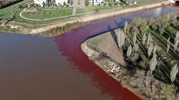
The Red River gets its name from the color of its water. This river was called by the name of 'Halys' which means salty stream in Ancient Times. This stream has hosted the vast majority of the civilizations established in Anatolia. For this reason, traces of every period of history can be found around the valley. For example, rock tombs, castles and bridges are just a few of them.
The Hittites named this river Marassantiya. The Kızılırmak, which shaped the western borders of Hatti, the main land of the Hittites, formed a border between Front Asia and the rest of Asia in ancient times.
The 'Battle of the Halys River' between the Medes and the Lydians in 585 BC also took place here.
Dams on the Red River
Some of the dams on the river are as follows:
Sarıoğlan
Yamula
Kesikköprü
Hirfanli
Kapulukaya
Altinkaya
Derbent
Obruk